BRIEFING 01 • PLUVIAL FLASH FLOOD DIAGNOSTICS
CRS: Arc 1960 / UTM Zone 37S (EPSG:21037)
Author: Daniel Macharia Njau, Lead EIA & GIS Consultant
1. Pluvial Flash Flood Risk in Dense Urban Catchments (Feb–May 2026 Seasonal Rains Analogue)
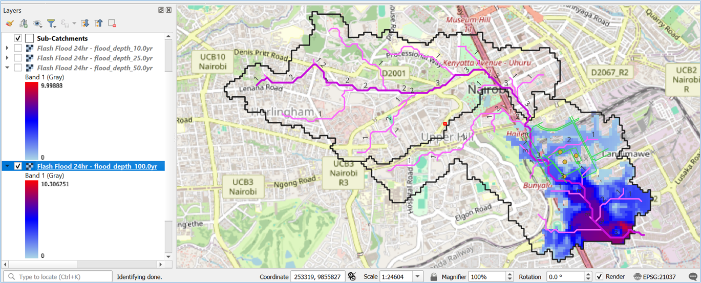
Situated within Nairobi’s Central Business District adjacent to Uhuru Highway and the Ngong River corridor, the 16.85-acre (6.82-hectare) Nairobi Railway City (NRC) MICE Core site occupies a downstream topographic basin receiving rapid runoff from high-elevation western ridges including Upper Hill, Hurlingham, and Lenana Road.
466.9 m³/s
100-Yr Peak Discharge (Qp)
7.14 m
100-Yr Max Pluvial Depth
34.68%
Catchment Inundation Area
CN 91–95
Composite SCS Curve Number
Spatial Modeling Framework & Soil Saturation Context
Hydrodynamic simulations were executed in QGIS using the Rain2Flood Analysis Plugin, integrating sink-filled SRTM 30m DEM elevation layers with daily and hourly rainfall grids recorded between February 1 and May 8, 2026 (including the March 6 cloudburst of 160 mm and historical station peaks of 534 mm at Dagoretti and Wilson Airport).
Early-season rains rapidly saturated Nairobi’s expansive "Black Cotton" vertisols (Hydrologic Soil Group D). Once wet, these clays swell and lose structural permeability, converting subsequent high-intensity convective storms into near-100% instantaneous surface runoff across compacted CBD surfaces.
Multi-Return Period Flood Diagnostics (24-Hour Storm)
| Return Period |
Annual Probability |
Peak Discharge (Qp) |
Catchment Submerged |
Site Operational Impact |
| 10-Year |
10% |
365.4 m³/s |
32.15% (6.38 m max) |
Localized street ponding and internal access corridor flooding. |
| 25-Year |
4% |
— |
Expanding lateral footprint |
Defines maximum safety threshold for secondary drainage mains. |
| 50-Year |
2% |
— |
Matches 160 mm cloudburst |
Structural threshold for primary MICE Arena foundation works. |
| 100-Year |
1% |
466.9 m³/s |
34.68% (7.14 m max) |
Severe backing out of culverts; threatens subterranean utilities and concourses. |
Key Engineering & Drainage Takeaways
- Early-Stage SuDS Prioritization: Accelerate installation of master-plan green buffers, peripheral bioswales, and temporary sediment retention basins to attenuate high-velocity street runoff during civil works.
- Subterranean Excavation Protection: Because 10-year convective events can accumulate over 6 meters of water in unpaved excavations, active foundation pits require continuous perimeter bunding and dedicated dewatering pumps.
BRIEFING 02 • MACRO-SYSTEMIC RIVERINE STRESS TEST
Catchment Area: 11.182 km² (Mean Slope: 8.22%)
Time to Peak (Tp): 6 Minutes
2. Macro-Systemic Riverine Flood Risk Under "Super El Niño" Conditions (1997/98 Historical Analogue)
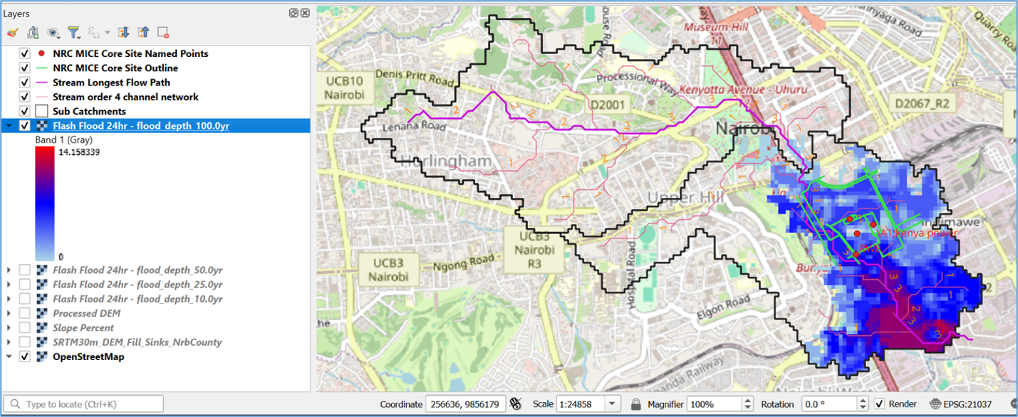
With WMO and IRI climate diagnostics projecting an 80% to 98% probability of a potent El Niño phase influencing East Africa’s October–December (OND) short rains, the MICE Core site was stress-tested against 6,144 hours of continuous meteorological data from the catastrophic 1997/98 Super El Niño event.
925.5 m³/s
100-Yr Peak Discharge (Qp)
14.16 m
100-Yr Max Flood Depth
46.63%
Catchment Inundation Area
6 Mins
Hydrograph Time to Peak (Tp)
Hydraulic Behavior & Overbank Propagation
Modeled across an 11.182 km² urban catchment (Curve Number 98, runoff coefficient 0.95, Manning’s n = 0.013), sustained 24-hour El Niño rainfall shifts the hazard profile from localized street ponding to massive riverine overbank flooding. Hydraulic backing along the Ngong River breaches standard 30-meter riparian buffers, propagating deep floodwaters westward toward Uhuru Highway and northward toward lower Bunyala Road.
El Niño Return Period Inundation Envelope
| Return Period |
Max Flood Depth |
Inundation Extent |
Significance for MICE Core Site |
| 10-Year |
10.49 m |
42.35% |
Significant overbank flooding of the Ngong River corridor. |
| 25-Year |
11.97 m |
43.80% |
Severe threat to perimeter access roads and temporary site works. |
| 50-Year |
13.07 m |
45.32% |
Critical hydrostatic threat to basement structural integrity. |
| 100-Year |
14.16 m |
46.63% |
Catastrophic inundation of the entire low-lying SPA basin (peaking at 943.9 m³/s). |
Mandatory Civil Engineering Safeguards for Late-2026 Construction
- Subterranean Works Lockout: Complete, waterproof, seal, and backfill all deep excavations and retaining walls for the 28,000 m² basement footprint prior to the October OND rains onset.
- Dynamic Coffer Dams: Engineer earth-filled geotextile coffer dams and heavy-duty flood bunds along the southern riparian boundary rather than relying on standard 30-meter riparian setbacks.
- 200% Dewatering Upgrade: Double automated diesel-powered backup dewatering pump capacities beyond seasonal baselines and position arrays above the flood envelope.
- Upstream Telemetry Early Warning: Install automated water-level sensors 2 km upstream in Upper Hill and central drainage channels linked to site sirens to ensure safe worker evacuation within the rapid 6-minute Time to Peak (Tp).